
Around & About the Ward of Aldersgate
A Walking Tour
Introduction
Devising a tour for a Ward Club, where participants are likely to be either familiar – or extremely familiar – with their area is always going to be a challenge, but in an unfortunate way it was made rather less difficult in two respects. The fact that much of the area was heavily bombed in World War II means that many buildings of interest that had survived earlier ages were destroyed and those that weren’t are relatively few and, therefore, more well known. So to achieve a tour that, hopefully, would include interest and even a surprise or two might be a possibility if I concentrated more on what had been lost and not what remains as being familiar. The Ward itself occupies a relatively small area, which gave rise to the title of the tour as we both started and finished outside its current boundary. There were ten ‘ports of call’ altogether and the following notes for each are set in the order in which we walked.

Had this been an illustrated talk, we could have looked at the way the area has changed over time in chronological order but, being a walking tour, you could be forgiven for thinking that what follows appears to be entirely haphazard. Which, of course, it is!
Click Here to visit the Master's original Event Report Page from October 2015.
But first, some background…... (click on the images to get an expanded view)
Aldersgate Ward and St Martin’s le Grand Liberty
The boundary of the Ward has altered over the years, most recently with minor changes at the northern and southern ends of Aldersgate Street (in 2013 I believe). The alignment of the City Wall meant that, at times, the Ward was known as Aldersgate Within and Aldersgate Without (the Wall) as is the case with Farringdon today. Stow’s plan of 1755 shows the line of the Wall and Aldersgate itself quite clearly, with St Martin le Grand’s Liberty to the south.

The term liberty originated in the Middle Ages, traditionally defined as an area of land where rights reserved to the king had been transferred into private hands. It later became a unit of local government administration. Liberties were areas that varied widely in extent, which were independent of the usual system of hundreds and boroughs for a number of different reasons, usually to do with tenure rather than geography. Consequently, areas covered by liberties could be widely scattered across a county or limited to an area smaller than, say, a single parish. Here, although the liberty lay within Aldersgate Ward at the time, it’s tenure was to Westminster Abbey with the Ward having no jurisdiction over it.
At the southern end of the plan ‘Blow Bladder Street’ can be seen. So called because the vendors of bladders inflated them, suspending them on poles or cords to dry, thus advertising their wares to purchasers. According to Strype: “Long strings of such inflated bladders of all sizes seen in bye-streets about Newgate Market and Smithfield and in the neighbourhood of the Central Meat Market. In 1720 the butchers and bladder-sellers had left Blowbladder Street, replaced by milliners, sempstresses, and such as sell a sort of copper lace, called St. Martin's lace, for which it is of note…”
Regarding other trades in the area, in addition to the major print industry described by Brian Heppell in his excellent walking tour for the Ward Club in 2014 (Click Here for an Event Report), historically, Long Lane was a centre for new and second-hand clothing (hence Cloth Fair) and the alleys and courts to the west of Aldersgate Street housed the Lace trade. In the C17, Little Britain was the location of booksellers for many years, particularly second-hand volumes. Many street names still provide echoes of former local trades throughout the City, for example: Honey Lane, just off Cheapside (where the Honey Market was located); and Paternoster Square, Ave Maria Lane and Creed Lane close to St Paul’s Cathedral, where religious texts were sold.
Stop 1: Hand & Shears, 1 Middle Street
Built originally in the C16, The Hand & Shears became established as a ‘Court of Piepowder’, which was a special court that sat in times of public markets or fairs in England in the medieval period. Such courts held exclusive jurisdiction over disputes between merchants and consumers and any other dispute arising as a result of the holding of a market or fair and upon fair grounds. The pub’s name is derived from the official opening of Bartholomew Fair by the Lord Mayor
cutting the first piece of cloth, clearly indicated by the large pub sign at first floor level. The present, listed building dates from circa 1830. Here, the fair in question was Bartholomew Fair, an annual 3-day (eve, day and morrow) fair held on the eve of St Bartholomew’s Day. The Priory of St Bartholomew established the fair under royal charter from Henry I in 1133 - 10 years after the priory itself was founded. It continued annually for over 700 years, at times lasting for two weeks, until it was suppressed in 1855 for debauchery!

Stop 2: Aldersgate Street’s Northern Boundary
Howell, writing in the middle of the seventeenth century, says: “This street resembleth an Italian street more than any other in London, by reason of the spaciousness and uniformity of buildings, and straightness thereof, with the convenient distance of the houses; on both sides whereof are divers very fair ones, as Peter house, the Palace now and mansion of the most noble Marquis of Dorchester. Then is there the Earl of Tenet's (Thanet's) House, with the Moon and Sun Tavern [s] very fair structures.'"
John Milton came to live here after his marriage to Mary Powell “...because there were few streets in London more free from noise…”
In 1720, Strype describes it as “...a Place of considerable Trade, it is a great Thoroughfare, and its Houses well built.”
We might be surprised to know that these descriptions are of Aldersgate Street in past centuries, but an illustration of the pillars marking the northern boundary of the Ward and the City as late as in 1874 shows far more consistency in scale and appearance than that seen today. Interestingly, the building immediately to the right of the right-hand pillar (see below) remains standing, albeit much altered.

Although the pillars have long since gone, an interesting clue remains on the west side of the street. Directly opposite the junction with Fann Street, two street signs can be seen close to each other at first floor level; to the left is ‘Aldersgate Street’, to the right is ‘Goswell Road’ in the ‘Borough of Finsbury’. These mark where the City boundary used to be located and where the Ward boundary still lies. Before the term ‘road’ came into common usage in the C16, the vast majority of thoroughfares had already been named.
Consequently there were no roads in the City of London, only streets, squares, alleys and so on. A boundary change in 1994 meant that Goswell Road became part of the Square Mile as far to the north as the junction with Baltic Street West. However, this section of Goswell Road lies within Cripplegate Ward, so the change in name from Street to Road still effectively marks the boundary of Aldersgate Ward.
Despite the extensive damage caused by bombing in World War II, there were still pockets of largely Victorian buildings on both sides of Aldersgate Street, as can be seen in this photograph (right), taken in 1963. One of the most notable things is the lack of traffic – a photo taken on a Sunday perhaps? In the distance the Underground sign at Barbican Station can be seen and beyond that the ‘tower block’ (modest by today’s standards) on the site then occupied by the London Salvage Corps. Although we will look

at buildings that formerly occupied those two sites shortly, the main thing to point out is that there is still a general consistency in appearance and balance on both sides of the street. Though, clearly, the street is not as grand and fair as in Howell’s time.
Stop 3: Beech Gardens, Barbican Podium
World War II & Post-war Redevelopment
Barbican Estate has been such a familiar part of the area for so long, it is understandable that many may not appreciate just how much of this part of the City was destroyed by bombing in the Blitz. The following three photographs show dramatically just how devastating the impact of such extensive bombing had upon individual buildings and whole areas of the Square Mile.


Perhaps the map below, showing the different degrees of damage caused by World War II bombing, provides the most graphic explanation of why so little of what might be called “historic Aldersgate” is to be seen today. Although Aldersgate Ward is not specifically marked, it is clear that much of it suffered the greatest degree of destruction (coloured purple). The swathe of bombing caused by flights that were routed north/south through the centre of the City was particularly devastating, as the map shows all too dramatically.
Although plans were already being considered for the reconstruction of London as a whole before the end of the war, it was in the 1950s that the first plans were presented to the Corporation of London for the development of the area now occupied by the Barbican. With the active support of the then Minister for Housing, Duncan Sandys, the Corporation accepted the concept of creating a major residential estate on the site. The Barbican’s design was refined in the period 1955 to 1959 and the arts centre element redesigned between 1964 and 1968. The development as a whole was built with modifications between 1962 and 1982 to the designs of Chamberlin, Powell and Bon.


A casual passer-by might wonder why the stone tablet on the wall at the northern end of the bridge crossing Barbican Lake beneath Gilbert House, which was unveiled by HM The Queen in 1972 to commemorate her and Prince Philip’s Silver Wedding, as it is in such an unprepossessing and, frankly, illogical position. The answer is that at that time to the north of this location the remainder of the development was either still under
construction or merely cleared land. The overall length of time taken to realise the Barbican was not only due to on-going labour disputes but also, in the case of the Arts Centre, the Corporation’s increasing concern regarding spiralling costs. It was only following the longest meeting of the Court of Common Council then on record that the Barbican Centre received the final go ahead. Fortunately, the arts centre had a true champion in its first director (during the years 1970-1990), Henry Wrong, who can be seen in the photo below viewing construction in the 1970s. In the background, St Giles Cripplegate and the Girls’ School (opened in 1969) can be seen and in the foreground the incredibly complicated construction of the Barbican Centre is clearly visible “with the lid off”.
The Queen formally opened the Barbican Centre in 1982 and in the intervening years, the estate has received both praise and criticism. Although many dislike the ‘Brutalist’ nature of its design and extensive use of bush-hammered concrete, it is notable for the extent and maturity of its landscaping, perhaps making what is a high density housing project far more palatable than many of its successors. The entire estate was ‘Listed’ in 2001, following the example of its predecessor, the Golden Lane Estate, also built by the Corporation to the north.

Stop 4: Junction of Aldersgate Street & Long Lane
134 Aldersgate Street (“Shakespeare’s House”) & The Fortune Theatre

Occupying the site of what is now Barbican Station, a building, which had formerly been the Half Moon Tavern, for many years bore a sign proclaiming it to be ‘Shakespeare’s House’ (visible below the second-floor bay windows on the photo left). Although the building was very close to the nearby Fortune Playhouse, there is no documentary evidence surviving to indicate that Shakespeare resided here. A subsidy roll (records of taxation in England made between the C12 and C17) from 1598 shows a William Shakespeare as being owner of the property, but there is nothing to indicate specifically that he was the famous playwright.
The Fortune, one of the celebrated - and one of the earliest - Elizabethan theatres, stood outside the Ward between Whitecross Street and Golding Lane (presumably now Golden Lane). In Golding Lane also stood the Nursery, a place for educating children for the profession of the stage, established in the reign of Charles II. Pepys' Diary contains the following two notices of the “Nursery”:
"2nd Aug., 1664. To the King's Playhouse… I chanced to sit by Tom Killigrew, who tells me that he is setting up a Nursery; that is, is going to build a house in Moorfields, wherein he will have common plays acted.
"24th Feb., 1667(8?). To the Nursery, where none of us ever were before; the house is better and the music better than we looked for, and the acting not much worse, because I expected as bad as could be; and I was not much mistaken, for it was so. Their play was a bad one, called ‘Jeronimo is Mad Again’, a tragedy."
Obviously theatrical criticism is nothing new! Interesting to note, in connection with The Nursery, that The Italia Conti Academy of Theatre Arts is, today, located nearby in Goswell Road.
Barbican Tube Station
Originally called Aldersgate Street Station when it opened in 1865, its name was shortened to Aldersgate in 1910 and renamed again in 1924 as ‘Aldersgate & Barbican’. On 1 December 1968 the station's name was simplified to Barbican. During World War II the station suffered severe bomb damage, particularly in December 1940. This led to the removal of the upper floors, the remainder of the street-level building being demolished in 1955. The present building is by Rolfe Judd (1987-89). It may come as something of a surprise

that the photograph (right) dates from 1971. In fact, although the last regular steam service ceased ten years earlier, a more recent steam train ran the original route to celebrate the 150th anniversary of the Underground in 2013.
Perhaps a rather more unnerving fact (and what, at first glance, is seemingly unconnected) is that the last public execution in England took place in May 1868 when Michael Barrett was hanged outside Newgate Prison for his part in the Clerkenwell Explosion in December 1867 (part of the Fenian uprising in that year). It was reported that a crowd of 2,000 onlookers booed and jeered and sang Rule Britannia and Champagne Charlie as his body dropped. The macabre fact is that the world’s first underground railway, which terminated at Farringdon Station, opened in 1863. This meant that for some five years, members of the public were able to travel by ‘Tube’ to see public hangings…
Manchester Hotel
At the corner of Aldersgate Street on the south side of Long Lane, the Manchester Hotel opened in 1879 (see right). It was for years a rendezvous for buyers and sellers from the provinces, especially from the North, and for visitors who came to ‘Town’ for football Cup finals (the London venues being Kennington Oval and, later, Crystal Palace Park). It was also used by juries sitting on murder trials at the Old Bailey, in one of the larger rooms they were locked up for the night under the protection of the City ushers.


Growing competition from new hotels in the West End before the First World War meant that in 1914 it closed its doors. It was commandeered by the Government and for a time was a hostel for Jewish refugees from Belgium and Poland. In 1919 it reopened following much modernisation and flourished once more. However, it was attacked by German bombs (again, in December 1940) and gutted by the subsequent fire. As with so many ‘bomb sites’, it remained cleared for a considerable time, as seen in the photo left, taken in 1958.
Stop 5: London House, Shaftesbury House & 153 Aldersgate Street (The Albion)
London House
Located on the west side of Aldersgate Street just north of the Museum of London Rotunda, the site is currently occupied by a block of apartments named London House, built in the 1990s I believe. Until 1639 the building occupying the site was called Peter’s (or ‘Petre’) House, due to it being the town house of Lord Petre. It was designated by Parliament as a prison in 1642 “for prisoners coming from Chichester” (I haven’t yet found out “why Chichester?”). In 1648 the House of Commons confined the MP, peer and poet Richard Lovelace here and the building continued as a prison during the Commonwealth under Cromwell. The See of London bought the building following the Great Fire for use by the Bishop of London, his residence in St Paul’s

Churchyard having been destroyed, and it consequently became known as London House. Here Bishop Compton lived and Princess (later Queen) Anne fled to London House from Whitehall at the time of the Revolution. Following different tenancies, Bishop Sherlock was given permission to sell the property in 1749. It was destroyed by fire nine years later and was rebuilt, but was finally demolished in 1871 and shops were built on the site. Although I have seen a C19 photograph of the later building, an image of the earlier London House has proved to be elusive. However, the plan of 1747 (see left) clearly shows a building of great prominence and, no doubt it was an impressive feature in Aldersgate Street for many years.
Shaftesbury House
Nearly opposite London House stood Dorchester House (the London residence of the Marquis of Dorchester), it was subsequently owned by the Earls of Thanet and described by Pennant as “a magnificent old house built about the time of Charles I” (actually by Inigo Jones in 1644). It then became known as Shaftesbury House, being leased or owned by Lord Shaftesbury, who (I love this quote) “attempted to get into the magistracy; but, being disappointed in his views, and terrified at the apprehension of the detection of a conspiracy he had entered into against his prince, fled in 1683, into Holland, where he soon died of the gout, heightened by rage and frustrated ambition.” In 1750 the house became a tavern, was later converted into a lying-in hospital and finally a dispensary. It was demolished in 1882 and now forms part of the present location of the Museum of London.

The Albion, 153 Aldersgate Street
Peter Cunningham in his Handbook of London (1850) describes The Albion as one of the largest establishments of the kind in London, and famed for its good dinners, both public and private, and also its good wines. The farewell dinners given by the East India Company to their Governors of India were generally given at the Albion, also several of the City Livery Companies hosted their dinners here; and here (after dinner) the annual trade sales of principal London publishers took place.

The Carpenters' Company in 1927 purchased property in Aldersgate Street consisting primarily of office and retail space, although one of the buildings had been a public house, The Albion Tavern (until it was closed in 1908). The buildings were severely damaged in the Second World War, and in 1958 the property was sold to the Corporation of London. The site of The Albion Tavern was close to the site of Shaftesbury House, a little north of the present Museum of London. This photograph of The Albion (see left) shows a building that, quite honestly, looks as though, stylistically, it might still have been built in the earlier C20.
Stop 6: Museum of London Rotunda Garden – The Bull and Mouth Inn
Although the Bull and Mouth Inn was located to the south (off Bull and Mouth Street where 1 St Martin le Grand now stands), a fragment of it can be seen in the sunken garden within the
Museum of London Rotunda. The site of the inn was subsequently occupied by the Queen’s Hotel on the front of which was “a statuette” of a bull, above which are the bust of Edward VI, and the arms of Christ's Hospital, to which the ground belonged. The stone tablet (shown right) is probably from the old inn, and on it the following lines are inscribed:
"Milo the Cretonian
An ox slew with his fist,
And ate it up at one meal,
Ye gods, what a glorious twist!"

The Bull and Mouth’s original name was, apparently, the "Boulogne Mouth," bringing to mind Henry VIII’s besieging of the town and harbour of Boulogne. One
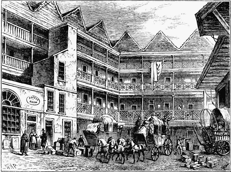
account suggests that the "gne," became generally pronounced by Londoners as "on," gradually becoming "an," with the ultimate addition of "d" thus making it "and". With the first syllable of the first word becoming "bull", it eventually resulted in "Bull and Mouth”. Certainly the ability of Milo to consume a whole bull at one sitting was more than matched by the inn yard of this famous hostelry (see right), as it ranked as the largest in London “and could hold 30 coaches."
Stop 7: Aldersgate
The gate, constructed by the Romans, was first recorded as Ealdredesgate. Certainly it was one of the four Roman gates of London – how it became known as ‘Aldersgate’ depends on which account you read!
Through this gate James I & VI entered the City to claim the throne after Elizabeth’s death in 1603. (The A1, the longest numbered road in the UK - of which Aldersgate Street is part - connects the capital of England and the UK, with Edinburgh, the capital of Scotland.) Having become dilapidated and dangerous, the gate was pulled down by order of the Lord Mayor; it was rebuilt in 1618 (at a cost of more than £1,000) through a legacy of William Parker, a merchant tailor. It was damaged in the Great Fire, but soon after it was repaired and ‘beautified’. Originally, like Temple Bar, it had an arch in the centre for general traffic, with a postern on either side for pedestrians, but over time pressure grew to widen the street and (as was also the case with Temple Bar) eventually the gate was sold and demolished.
A blue commemorative plaque confirming the demolition of Aldersgate in 1761 can be seen on the east side of the street next to the Lord Raglan PH, on the front of which can be read the phrase “built on tradition”. Indeed, this is true in more ways than one it seems! The website for the Lord Raglan describes it as “one of the oldest sites in the city. Rebuilt after the Great Fire of London, it was originally known as ‘The Mourning Bush’ but later changed to Lord Raglan” and that it “Still retains much of its original features… including the remains of an old Roman Wall in the cellar”. Although I have never been into its cellar, click on the button below to see a map taken from Historic England’s website (formerly English Heritage) – I warn you that it may take a while to load:
There you will see that, as recorded on the National Heritage List for England, the fabric of a section of the Roman wall and Roman, medieval and post-medieval gateway at Aldersgate is still located beneath the present road, a Scheduled Ancient Monument. So, you can still stand on, and drive over, what remains of the gate.
But what did the gate look like?
Over the arch was a figure in high relief of James I, with the imperial arms mounted above, but the building itself “was heavy and inelegant”. On the eastern side was an effigy of the prophet Jeremiah, and these lines from his prophecies: "Then shall enter into the gates of this city kings and princes, sitting upon the throne of David, riding in chariots and on horses, they and their princes, the men of Judah, and the inhabitants of Jerusalem; and this city shall remain for ever." In the western niche was an effigy of Samuel, with this inscription: "And Samuel said unto all Israel, Behold, I have hearkened unto your voice in all that you said unto me, and have made a king over you." On the south side was a bas-relief of James in his royal robes. In other words, the appearance of the gate when approaching the City of London was far more elaborate and
imposing than its ‘inner face’. Combined with the heads of traitors’ heads being impaled on pikes on the southern gate to London Bridge and some other entrances to the City – the impressiveness of Aldersgate’s ‘external’ appearance was clearly intended to form part of the message to those approaching the Square Mile that ‘this is a city of great wealth, tradition and power and wrong-doers had better beware’.
One of many illustrations of Aldersgate’s appearance when approaching the City is shown in the engraving (right) and one could speculate that it might have been one of the images examined by the artist John Piper.

It is known that Piper examined images of City Gates in the Guildhall Print Collection for a commission to design a tapestry in 1978 for Sedgewick. Having prepared the design, Piper produced a Limited Edition of 100 prints (his largest) for Sedgewick to present to their major clients. The next image shows the finished design with Aldersgate featuring second from the left. The original tapestry is now held in the Guildhall Collection.

Stop 8: Postman’s Park
Postman's Park opened in 1880 on the site of the former churchyard and burial ground of St Botolph's Aldersgate church and was expanded over the next 20 years to incorporate the adjacent burial grounds of Christ Church Greyfriars and St Leonard, Foster Lane. A shortage of space for burials in London meant that corpses were often laid on the ground and covered over with soil, thus raising the level of the park above the streets surrounding it. It is so named, because of the close proximity of the grand buildings of the General Post Office. These included what is now 1 St Martins le Grand and the King Edward Building, behind which the GPO’s main sorting office was located and beneath which still lies the underground rail link to Mount Pleasant. The park was as popular a lunchtime location with the postal employees as it remains with today’s City workers and visitors.
The George Frederic Watts Memorial to Heroic Self Sacrifice
An admirer of royalty, Watts proposed, in 1887, to mark Queen Victoria’s Golden Jubilee by creating a Memorial to Heroic Self Sacrifice to commemorate ordinary people who had died saving the lives of others, and who might otherwise have been forgotten. He said: “the national prosperity of a nation is not an abiding possession, the deeds of the people are.” The scheme was not accepted at that time, but in 1898 Watts was approached by Henry Gamble, vicar of St Botolph's Aldersgate church. He suggested the memorial could be created in Postman's Park in the City of London.
The memorial was unfinished when unveiled in 1900; consisting of a wooden loggia (designed by architect and painter Ernest George), sheltering a wall with space for 120 ceramic memorial tiles to be designed and made by William De Morgan. Only four of the memorial tiles were in place in 1900 and when Watts died in 1904, his widow Mary took over the running of the project,

overseeing the installation of a further 35 memorial tablets in the following four years. Later she apparently became disillusioned with a new tile manufacturer and was increasingly occupied by the running of the Watts Gallery. Only five further tablets were added during her lifetime. However, his widow added a central niche with a tiny wooden statuette of Watts in robes by T. H. Wren, in 1907.
Following the 2004 film Closer, based on the 1997 play of the same name by Patrick Marber, Postman's Park experienced a resurgence of interest; key scenes of both were set in the park itself. In June 2009, a city worker, Jane Shaka (née Michele), through the Diocese of London added a new tablet to the Memorial, the first to be added to this ‘Listed’ structure for 78 years. In November 2013 a free mobile ‘App’, The Everyday Heroes of Postman’s Park, was launched documenting the lives and deaths of those commemorated on the memorial. Further information of the Watts Memorial maybe found at the Postman's Park website - Click Here.
Stop 9: Bank of America Merrill Lynch & Christchuch Greyfriars, Newgate Street
Following the decision of the GPO to move out of its properties in the City, different proposals were put forward for the redevelopment of a series of buildings known as the King Edward Building just to the west of Aldersgate Ward. The complex included a grand public post office building on King Edward Street (which also housed the Postal Museum), a huge sorting office behind; at the back of which was located a large yard where delivery vans came and went via Giltspur Street and an imposing façade on Newgate Street next to the Victorian terrace opposite the Old Bailey.
Early proposals were unsuccessful; not least of all because the overall site was affected by a large number of planning policies protecting the architectural and historic significance of the physical fabric, both on the site and located nearby. They comprise: the Strategic Views of St Paul’s, St Paul’s Heights controls, St Paul’s Depths controls, the site impinged upon two conservation areas, redevelopment of the site affected the settings of listed buildings on and near the site (including the Old Bailey), the location of nearby Scheduled Monuments and, to cap it all, the entire King Edward Building complex was listed Grade II*!
Early discussions with Merrill Lynch (now Bank of America Merrill Lynch), who wanted to locate the headquarters for their European, Middle East and African operations on the site, proved difficult to resolve. However, in time the American architectural practice for the scheme, Swanke Hayden Connell, formed a London-based office and in due course, cooperation between all parties and authorities developed an approach based on teamwork. The most crucial moment, in my view, was when it was agreed by English Heritage that the sorting office might be demolished. Although listed Grade II*, this status was due to the method of construction of the buildings (‘Hennenbique’), using reinforced concrete. A representative section contained within the building on King Edward Street was retained and this ‘unlocked’ a development, officially opened on 1 January 2001 that achieved: a total floorspace of 830,00 sq. ft. which included
two of the biggest trading floors in Europe at that time (providing 2,200 trading positions); the refurbishment of King Edward Building; the refurbishment of the Newgate Street Victorian terrace and the listed GPO façade next to it; the reinstatement of the ‘footprint’ of Wren’s Christchurch Greyfriars; the refurbishment of Christchurch Churchyard and the enhancement of both the Newgate Conservation Area and the setting of the Old Bailey.

Oh, and something else…
Stop 10: Roman City Wall & Medieval Bastion, Giltspur Street
A Medieval corner bastion where the City Wall swept abruptly south, together with a short stretch of the Roman wall itself, was excavated in 1909. Although it was retained in situ, until the redevelopment of the King Edward Building complex described above, for decades it sat in a waterlogged chamber on the top of which lay the Tarmac of the GPO delivery van yard off Giltspur Street. The only (rather obscure) clue to its existence was a modest and unattractive brick structure in the yard, which housed the access staircase leading to the chamber. Remains of two more bastions were excavated in 1908-9 and those of another in King Edward Street were uncovered in 1887, but none of these were preserved. In fact, the strength of their construction was such that explosives had to be used to destroy them.
The other thing that was achieved as part of the ‘Merrill Lynch’ development was what is now effectively a part of hidden London (and one of the most exciting in my view). This was the retention, refurbishment and consolidation of these Roman and Medieval remains of the City Wall. Not just that, but also the fact that they are housed in a purpose-designed chamber, whose climate is carefully controlled AND available to the public to visit. I kept this part of the walk as close to my chest as possible, so that participants would end their walking tour with something that was not just a surprise, but also a genuinely impressive one too. The Master, Ron Wood, and Immediate Past Master, Jan Yerbury, were party to this, but I was delighted that of the other 40 participants who came on the walking tours, not one knew of the existence of these remains and only one said that she had guessed before we went into the chamber that archaeology might be what we were going to see.

The City Wall was one of the largest construction projects carried out in Roman Britain, built largely from Kentish ragstone brought by water from Maidstone. It has been calculated that approximately 1,300-barge journeys were required to transport the 85,000 tons of stone required from Kent. The wall was 2 miles long, enclosed an area of about 330 acres; was 6 to 9 feet wide and about 20 or so feet high. It had a ditch or fossa in front of the outer wall, measuring
some 6 feet deep by between 9 and 15 feet wide. In the chamber today, the Roman wall stretches for 12 feet and its full width survives as the base. It leans outwards and, seemingly, was leaning and cracked before the medieval bastion was added between 1250 and 1360. The
bastion is hollow with ragstone set in white mortar; the external face being carefully pointed and smooth, the inner face irregular and unpointed. Next to these remains is a carved stone bearing the inscription: “This stone was laid on August 25th in the sixth year of the reign of George IV. John Malcott mason.” The Museum of London has identified this as a foundation stone for the GPO East building erected on St Martin le Grand in 1826.

If you would like to know more about the City Wall, the following links may be of interest:
Postscript
I am most grateful to the Master, Ron Wood, for his support of, and enthusiasm for, these walking tours and to Ward Club member David Herbert for asking me to provide this narrative to go on the Aldersgate Ward Club’s excellent website. I am also delighted that so many wanted to participate in the tours and share my enthusiasm in the history and buildings of this part of the Square Mile.

In the time available on the two days concerned, it wasn’t possible to include everything set out above, for which I apologise – in fact, we could have spent the whole afternoon at just one of the ten ‘stops’ and still only scratch the surface of the remarkable history of Aldersgate Ward. There is so much more information still to be discovered and shared…
Jeff Kelly
October 2015